
Groundwork Milwaukee Connects the Dots on Flood Risk, Climate Change, and Public Health

Young Kim, Executive Director, Groundwork Milwaukee
If you’ve heard of Groundwork Milwaukee, you might associate them with urban agriculture, specifically stewards of community garden plots across the city, rather than with issues of climate change and public health. But Young Kim, the Executive Director of the organization’s Milwaukee chapter, says the Groundwork mission is much broader and international in scope.
The Origins of Groundwork
In 1980’s England, communities across the country were struggling under the weight of a depressed economy characterized by high rates of unemployment, disaffected youth, and increased crime. Liverpool sat at the epicenter of this milieu. It was once “the world’s factory… they made everything,” said Kim. The city had become an environmental wasteland, littered with vacant lots, abandoned factories, and neglected public parks. In response to this degradation, citizens rose up, with youth being a central element in their coalition, and began the hard work of restoring their community. Groundwork was born.
Fast forward ten years. Their efforts were “wildly successful” according to Kim, and affiliates, called “Trusts” spread to 50 cities across the United Kingdom.
Soon after, in 1998, the U.S. National Park Service and Environmental Protection Agency took notice and brought Groundwork stateside, setting up 3 chapters in New England after which it quickly took root in 22 cities across the country. Groundwork Milwaukee incorporated in 2007 and merged with Milwaukee Urban Gardens in 2011, hence their connection to the resurgence of the urban agriculture movement in the 1990’s.
“The environment and greening have always been a part of the Groundwork mission” says Kim, so the merger was a natural fit.
Now, they are setting their sights on the very real and urgent matter of building resilient communities that can stand up to the effects of climate change, flooding in particular.

“There are so many storm clouds on the horizon and we are uniquely positioned to use nature based solutions that will insulate people from these dangers,” says Kim. These solutions include building green spaces, planting trees strategically, and building stormwater retention systems, efforts that will supplement the city’s climate and equity plan. But the city is a big place, and Kim knew they had to focus their energy and resources.
Flooding, climate change, and public health: Connecting the dots
Climate change is no longer in the distant future. One need only look at the devastating floods in California or hurricanes that battered Puerto Rico and Florida in late 2022 to understand that. But the ravages of climate change hit close to home as well.
The rise in temperatures lead to heavier downpours and floods.
An article series on human health, climate change and social justice from Outrider and the Wisconsin Health Professionals for Climate Action (WHPCA) explains, “Climate breakdown will… exacerbate flooding woes. Warm air holds more moisture, which leads to more precipitation and more extreme rain events. In southern and western Wisconsin, annual precipitation is now 7 inches more than the 1950 – 2006 average.”

Percent change in total annual precipitation across the U.S. according to the 4th National Climate Assessment.
The human costs of these trends is significant. Drowning and electrocution are serious risks, but according to a bulletin from the CDC, “Flood waters can carry dangerous contaminants and overwhelm drainage systems and wastewater treatment systems, increasing the risk of exposure to bacteria, parasites, and unhealthy pollutants.” Waterborne illnesses and exacerbation of existing chronic conditions like diabetes and asthma can result.

Victoria Gillet, MD, member of Wisconsin Health Professionals for Climate Action
Milwaukee’s Flood Maps
What began as an effort to examine how Groundwork Milwaukee’s garden plots were being used expanded in scope to determine if their nature-based greening programs were being allocated according to the communities’ needs.
That was the genesis of the Milwaukee Flood Vulnerability Assessment, which tells a story through interactive maps and graphics about:
Flood exposure - where flooding is most likely to happen
Flood vulnerability - which neighborhoods will suffer the worst outcomes in the event of a flood
To identify the public health risk factors at play, Groundwork Milwaukee partnered with the Wisconsin Health Professionals for Climate Action (WHPCA) to gather data from the City of Milwaukee.
“There’s a ton of work being done in Milwaukee on health promotion and climate resilience strategies” says Victoria Gillet, MD a primary care physician working in Milwaukee and member of the WHPCA. “We care about where the flooding happens, but we also care about which people in our communities are most at risk for negative health consequences in the event of a flood.”
Eventually, Gillet is hopeful that tools like the Milwaukee Flood Vulnerability Assessment will inform clinical practice, and help health professionals advocate for a broader array of interventions for their patients.
The data they collected helped the team identify vulnerabilities in three categories:

Health risk factors include the prevalence of chronic disease, the percentage of residents with a disability, or lack of access to health insurance. Chronic conditions like heart disease, diabetes, asthma and poor mental health will worsen, or even become deadly in a flood event.
Socioeconomic factors such as poverty-level wages, lack of a high school diploma, the percentage of residents who identify as BIPOC, and the concentration of very young or very old people in the population directly impact a community’s ability to recover from a flooding event.
Housing vulnerability takes into account whether occupants own a car, live alone, and the age of a home, specifically if a home was built after 1950 when building standards became more strict. Without a car, evacuation of flooded areas takes longer and results in increased exposure to air and waterborne diseases.
The Intersection of Historical Housing Policy and Present-Day Flood Vulnerability
Many Wisconsinites are familiar with the fact that Milwaukee ranks as one of the most segregated cities in the United States. This unfortunate status is no accident, but a result of historical government housing policy from the 1930’s. The goal of the policy was to slow down the rate of foreclosures that ran rampant in the years following the Depression.
The government-sponsored Home Owner’s Loan Corporation (HOLC) issued bonds to help homeowners refinance their mortgages but some were left out. Neighborhoods were graded based on a number of criteria, including race and national origin, to determine the level of lending risk, as follows.

HOLC map of Milwaukee.
A - The “best” neighborhoods (green) were described as “hot spots” and the safest places to funnel investments.
B - “Still desirable” (blue) neighborhood worthy of investment
C - “Definitely declining” (yellow) grades were assigned to neighborhoods where there was “obsolescence [and] infiltration of lower grade population.” Investors were advised to exercise “extreme caution” when considering these areas.
D - “Hazardous” (red) neighborhoods were “characterized by detrimental influences” and an “undesirable population.” The government advised investors to avoid making investments in these areas.
Referred to as redlining, this discriminatory housing policy led to historic levels of disinvestment in neighborhoods housing black, Jewish, and immigrant populations, codifying the level of segregation we see today in Milwaukee and other major metropolitan areas across the country.
The legacy of this policy still burns: redlined neighborhoods, overwhelmingly inhabited by low-income BIPOC residents, are vulnerable to the worst outcomes of a 100-year flooding event.
For more information, see “Mapping Inequality: Redlining in New Deal America.”
Groundwork Milwaukee’s Young Kim uses Geographic Information System (GIS) maps created by the Urban Systems Lab at the New School in New York City to demonstrate some of the environmental hazards that make neighborhoods more vulnerable.
Ground temperatures: Five years of temperature data from June-August, 2010-2015, show ground temperatures 5 degrees hotter in redlined neighborhoods: 88 F vs. 92 degrees in redlined neighborhoods. “You touch the asphalt on a hot day in a parking lot at midnight, and it’s still warm and radiating heat,” says Kim.
Tree canopy and impervious surfaces. The tree canopy is significantly less dense and swaths of impervious surfaces--hard surfaces that don’t drain water and retain heat--cover the landscape of redlined neighborhoods
Historical bodies of water. The maps show historical bodies of water that existed 25 years before the civil war. In a major flooding event, many of the redlined neighborhoods are buried under more than 2 feet of water. “In the neighborhoods we identified, 2 feet of water will send some families into a tailspin,” said Kim. They’re worried about the potential of a Hurricane Katrina-like impact. “A lot of those neighborhoods, like the Ninth Ward in New Orleans have not recovered.”

The Eye of the Storm: Metcalfe Park
When Kim visits church and community groups to share the data, everyone wants to look at their own neighborhood, and find the street they live on. A natural response to be sure. But he encourages a broader view and asks. “Where are the most vulnerable places in Milwaukee?”
The maps highlighted a few tracts with both high exposure and high vulnerability to flood disasters. At its center lies the Metcalfe Park neighborhood, bordered on the east by 27th St., on the west at 38th St, North Ave. and Center St. are the south and north borders, respectively. The 30th street industrial corridor runs right through its center, and Brownfield remediation sites dot its eastern half.

Metcalfe Park neighborhood boundaries according to Milwaukee Neighborhood Identification Project (2000). Metcalfe Park is located to the northwest of downtown Milwaukee and is bound by 27th St. (east), 38th St. (west), Center St. (north) and North Ave. (south).
According to Chris Kennedy of the Urban Systems Lab at The New School in New York City, the partnership with Groundwork Milwaukee will continue as they capture more data. “We want to examine the location of the brownfield remediation and toxic sites to see what the impact of flooding will be on groundwater contamination.”
Current residents of Metcalfe Park are overwhelmingly young and old, live in homes built before 1950, have high rates of chronic disease and asthma, and many lack access to a car or other reliable transportation. 98% of the population identifies as Black, Indigenous, and People of Color (BIPOC).
They are vulnerable to the worst health outcomes and even death in the event of a major flooding event.
Next steps
“The point of all these maps is information,” says Kim. He believes in the power of sharing the data with church groups, neighborhood groups, and concerned citizens. It’s the first step in building sustainable, nature-based, health-promoting solutions.
Ultimately, Groundwork Milwaukee needs to secure funding to make the necessary investments that will prevent catastrophe in Metcalfe Park and other neighborhoods at greatest risk.
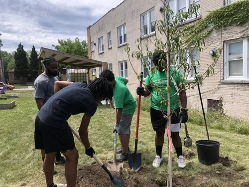
GroundCorps team members planting trees, which will help to control stormwater runoff, erosion, and pollution in water supply. This is one of many green infrastructure construction priorities that GroundCorps team members are trained in.
Some of the infrastructure for starting greening projects is in place already. Groundwork Milwaukee has a program called GroundCorps for young adults aged 19-25, who are paid well as they learn how to build green infrastructure, garden beds, plant and maintain trees. They are trained on landscaping, contracting, how to read a drawing, and how to interpret ADA regulations to build parks and other green spaces. Interested young people can apply now for open positions.
Kim and his staff have been working with the Metcalfe Park Community Bridges neighborhood association. They are having conversations now on what to build, but it’s important, says Kim, “that we work side-by-side, and not lead. The people have to want it.”
They’re making progress. Recently, Groundwork Milwaukee was awarded a grant from Groundwork USA to, according to the grant award announcement, “install climate resilience and mitigation infrastructure, including bioswales, trees, garden installations, and stormwater management systems, on five pocket park sites.” GroundCorps will be charged with completing these projects.
They are also hoping to acquire funds set aside in the Inflation Reduction Act for climate change mitigation and clean energy projects.
These are small steps that will, bit by bit, protect the neighborhood from the worst impacts of a flood.
“In concentrating on Metcalfe Park, we are looking to create a model,” says Kim. “We want to dig 2 feet wide, and 2 miles deep. Go deep. Employ residents, build relationships, and learn from 3-5 years of working intensively in one neighborhood. As we begin to see success, to see real beauty in the neighborhood, the work becomes self-evident, and another neighborhood will say ‘hey, we want to work with you.’” That’s how to make progress.
Groundwork staff is available to speak with your group. Contact Groundwork Milwaukee at 414-763-9947 or info@groundworkmke.org